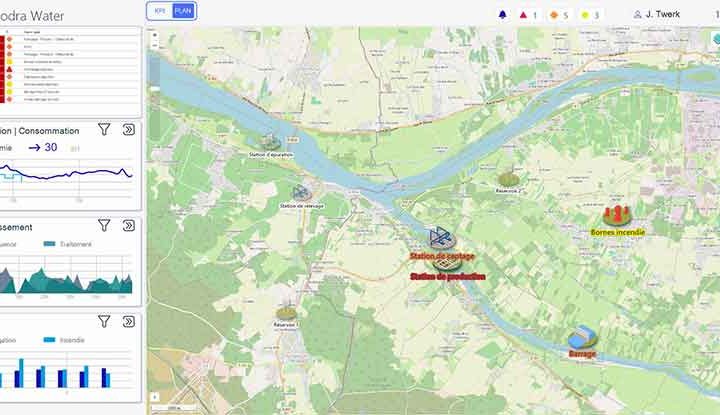
Geographic information systems (GIS) have become essential for designing intelligent, sustainable developments. By combining spatial analysis, dynamic visualisation and real-time SCADA, they are laying the foundations for GeoSCADA, an integrated approach that unifies mapping and operational management. This convergence makes it possible to monitor, analyse and act directly on infrastructures – from industrial sites to connected cities. In 2025, understanding the strategic role of GeoSCADA in multi-scale territorial planning has become essential.
GIS for intelligent planning: a multi-scale case study
Geographic information systems (GIS) have become essential for designing intelligent, sustainable developments. By combining spatial analysis, dynamic visualisation and real-time SCADA, they are laying the foundations for GeoSCADA, an integrated approach that unifies mapping and operational management. This convergence makes it possible to monitor, analyse and act directly on infrastructures – from industrial sites to connected cities. In 2025, understanding the strategic role of GeoSCADA in multi-scale territorial planning has become essential.
The central role of geographic information systems in spatial planning
A geographic information system does more than just produce maps: it structures, analyses and visualises complex spatial data to inform decision-making. Thanks to GIS, local authorities, industrialists and campus managers have a powerful tool at their disposal for planning their territory.
Geographic information systems can also be used to optimise the design and management of infrastructure, including transport networks, energy distribution circuits and public services. Finally, by accurately assessing the environmental impact of development projects, GIS facilitates more sustainable planning that respects local ecosystems.
Integrating GIS into a SCADA system like Panorama E2 opens the way to unified, dynamic infrastructure management. The map is no longer just a visual medium: it becomes an interface for action at the heart of the management system. By combining spatial data with real-time field data (water, energy and traffic networks, etc.), Panorama makes it possible to pinpoint anomalies, interact with equipment and take targeted action. In this way, GIS becomes a strategic component of a global SCADA tool serving the local area.
Practical examples of using GIS and Panorama at different scales
Smart city
In a medium-sized town, the combination of a geographic information system and Panorama SCADA makes it easier to :
- Traffic monitoring: traffic lights, street lighting and parking sensors are displayed on an interactive map. In the event of a malfunction (traffic lights out of order, lighting failure), technical staff can quickly intervene in the area concerned.
- Detecting anomalies in drinking water networks: connected sensors transmit information to Panorama, enabling a leak or drop in pressure to be identified immediately.
- Emergency response management: by cross-referencing spatial data and alerts from the field, technical services can intervene more quickly and in a targeted manner.
Industrial site
On a complex industrial site, such as a chemical plant or data centre, SCADA of critical infrastructures can no longer be limited to lists of alarms or technical dashboards. Thanks to Panorama’s GIS integration, the status of networks (water, gas, electricity, ventilation, etc.) can be viewed directly on an interactive map of the site. Each alarm, sensor or piece of equipment is located geographically, so operators can immediately put events into context.
In the event of an incident, they can access the area concerned in just a few clicks, identify the equipment affected and deploy teams on the ground more efficiently. Data logging coupled with spatial visualisation also facilitates post-incident analysis and preventive maintenance, while reducing risks and downtime.
Campus
Campus management involves the continuous monitoring of a large number of facilities spread over a wide area: buildings, lighting, access, green spaces, internal roads, etc. By integrating GIS into Panorama, managers have access to a single interface combining technical and geographical data.
For example, they can monitor energy consumption by building, view security alarms in real time or plan maintenance work based on the location of incidents. In this way, GeoSCADA facilitates intelligent, responsive site management, while supporting the objectives of energy efficiency and quality of life on campus.
Innovations and challenges for geographic information systems
Web mapping platforms and map servers now enable shared access to GIS data. Panorama reinforces this dimension by making data accessible in real time to decision-makers and technical teams, on site or remotely.
Geographic information systems are evolving rapidly with the advent of 3D modelling and simulation. Volume visualisation of buildings, underground networks and landscaping means that the impact of urban projects can be anticipated more accurately. Coupled with Panorama SCADA, this approach offers a realistic representation of the territory and facilitates strategic decision-making.
Artificial intelligence is also enhancing GIS capabilities, by automating anomaly detection, anticipating natural hazards and optimising resource management. However, to fully manage these advances, major challenges remain, including real-time data integration, securing sensitive information and increasing user skills.
Geographic information systems, enhanced by SCADA tools such as Panorama, are transforming land management. By providing a precise view in real time, it enables infrastructures to be optimised, risks to be anticipated and more sustainable and intelligent development to be supported.


